
couplesfamiliesphotographersoutdooraccessible
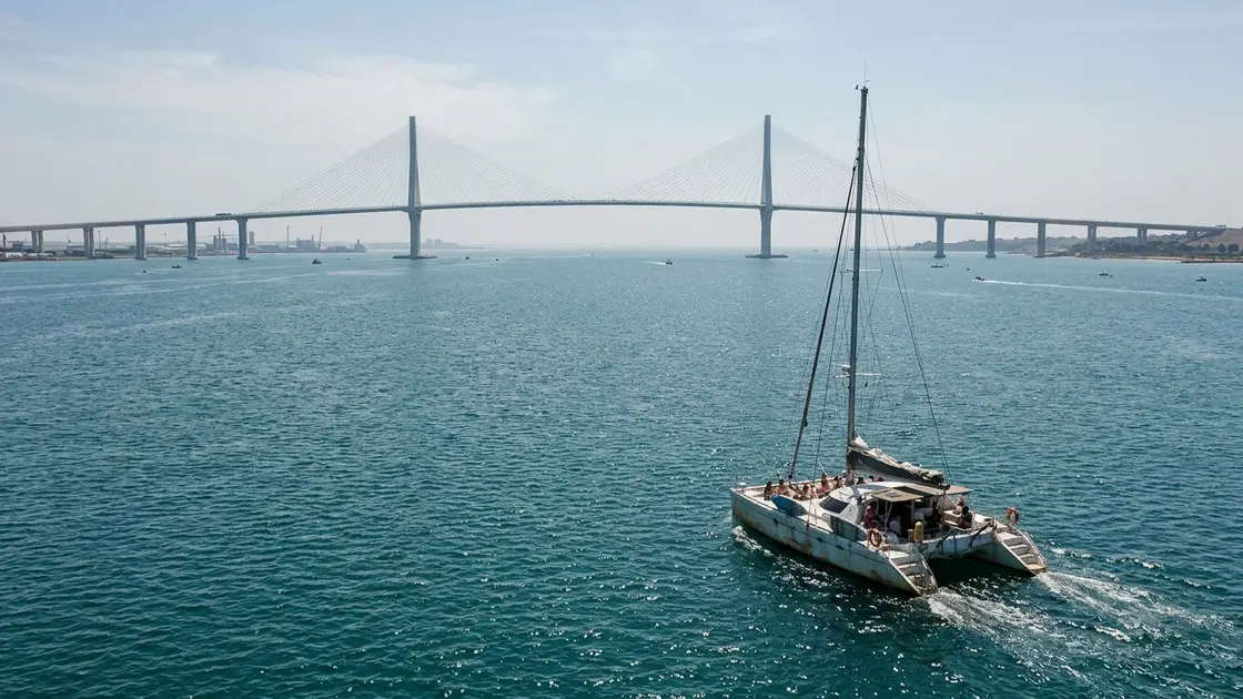
Catamaran cruising across the Bay of Cádiz towards the cable-stayed Puente de la Constitución de 1812
tour

Bay of Cádiz Boat Tour

Cruise the Bay of Cádiz from Muelle Comercial: pass the 1672 Baluarte de la Candelaria, sail under the 69 m La Pepa bridge, and compare ferries and tours.

Stepping onto a catamaran at the Dársena de Cádiz ciudad changes how the peninsula makes sense. From the street, the historic centre feels hemmed in by limestone sea walls, but out on the water the 111-square-kilometre outer bay opens into a broad arc connecting Rota, El Puerto de Santa María, Puerto Real, San Fernando, and Cádiz itself. Since antiquity, this sheltered inlet has served as the closest natural harbour to the Strait of Gibraltar and the mouths of the Guadalquivir and Guadalete rivers. When King Philip V moved the Casa de Contratación here from Seville in 1717 after the Guadalquivir silted up, the bay gained the monopoly on trade with the Americas and entered its eighteenth-century golden age.

From Muelle Comercial to the Western Sea Walls

Leisure catamarans and public ferries cast off from the commercial docks beside Plaza de San Juan de Dios and Plaza de Sevilla on the edge of El Pópulo, part of a port system unified by Royal Decree in 1982 under the Port Authority of the Bay of Cádiz. As the boat clears the harbour basin, the northern shoreline reveals the defensive ring built when seventeenth-century transatlantic wealth drew repeated naval and pirate raids:

  • Baluarte de San Felipe and the harbour entrance bastions guarding the port channel.
  • Baluarte de la Candelaria, erected in 1672 on a rocky promontory with casemates built into its outer sea walls and two nineteenth-century pavilions.
  • Alameda Apodaca and Parque Genovés, whose waterside gardens lead west toward La Caleta beach between the Castillo de Santa Catalina and the Castle of San Sebastián.

Under the 2015 La Pepa Bridge and the Inner Bay

Heading into the 26-square-kilometre inner bay toward the 1969 Puente José León de Carranza, tours pass directly beneath the Puente de la Constitución de 1812 (known locally as La Pepa). Designed by civil engineer Javier Manterola and inaugurated on 24 September 2015, the cable-stayed crossing stretches 3,092 metres in total—with 1,440 metres over the water and a 540-metre main span held by 187.1-metre and 181.24-metre pylons. Its 69-metre vertical marine clearance ranks among the highest in the world, allowing tall-masted vessels and large ships into the inner basin, where the tidal channels and salt marshes of the Bahía de Cádiz Natural Park meet the Caño de Sancti Petri and Río San Pedro. If you only want a point-to-point crossing rather than a guided cruise, the bay is also the only metropolitan area in Spain with passenger boats integrated into its public transport network, running regular lines to El Puerto de Santa María and Rota.

Reporter notebook

Insider tips

Best time

Pick sunset for old-town light or morning for calmer water

Book the late-afternoon or sunset catamaran when the Atlantic light hits the yellow dome of the Cathedral and the western sea walls; morning sailings generally enjoy calmer water before the afternoon breeze builds across the 111 km² outer bay.

Photo spot

Stand on the foredeck beneath Pylon 12 of La Pepa bridge

Stand on the open foredeck as the vessel approaches Pylon 12 of the Puente de la Constitución de 1812—looking straight up at the 187.1-metre water tower and 176 stay cables gives the best sense of the bridge's 69-metre vertical clearance.

What to bring

Pack a windproof layer for the open bay breeze

Even on warm afternoons in town, wind funnelling between the Strait of Gibraltar corridor and the open bay cools the deck quickly; pack a windproof layer and sunglasses with a strap.

Practical information

Duration
1.5–2 hours
Schedule
Daily departures from Muelle de Cádiz (morning, afternoon, and sunset sailings; metropolitan bay catamarans also run regularly to El Puerto de Santa María and Rota)
Price
From €19
Meeting point
Puerto de Cádiz (Muelle Comercial / Dársena de Cádiz ciudad, next to Plaza de Sevilla and Plaza de San Juan de Dios)

Frequently asked questions

Where do Bay of Cádiz boat tours and catamaran cruises depart from?

Sightseeing catamarans and metropolitan ferries depart from the Dársena de Cádiz ciudad (Muelle Comercial and Muelle Alfonso XIII) inside the Port of Cádiz. The boarding pontoons sit directly opposite Plaza de Sevilla and Plaza de San Juan de Dios on the eastern edge of El Pópulo, a flat five-minute walk from the train and bus stations.

What landmarks and bridges do you see on a Bay of Cádiz boat tour?

Depending on whether your route heads into the inner bay or along the northern seafront, you pass the 2015 Puente de la Constitución de 1812, the 1969 Puente José León de Carranza, the 1672 Baluarte de la Candelaria, Baluarte de San Felipe, and the waterside gardens of Alameda Apodaca and Parque Genovés towards La Caleta.

How high and long is the Puente de la Constitución de 1812 (La Pepa bridge)?

Designed by engineer Javier Manterola and opened on 24 September 2015, the Puente de la Constitución de 1812 spans 3,092 metres in total, with 1,440 metres over the water and a 540-metre main cable-stayed span. Its two main pylons reach 187.1 and 181.24 metres, holding the deck 69 metres above the water for tall ships.

Can you take a public ferry across the Bay of Cádiz to El Puerto de Santa María or Rota?

Yes. The Bay of Cádiz is the only metropolitan area in Spain with passenger boats integrated into its public transport network. Regular public catamarans link the Cádiz port terminal with both El Puerto de Santa María and Rota across the outer bay, offering an affordable commuter alternative to guided sightseeing and sunset cruises.

Further reading

Sources

15 references Show
  1. Wikipedia — Bahía de Cádiz (opens in a new tab)

    “Los municipios cuyos términos delimitan el arco de la bahía son Rota, El Puerto de Santa María, Puerto Real, San Fernando y Cádiz.”

  2. Wikipedia — Bahía de Cádiz (opens in a new tab)

    “Por ella discurren el caño de Sancti Petri y el río San Pedro, además de presentar grandes extensiones de marismas y esteros. Gran parte de la bahía está protegida bajo la figura jurídica del parque natural de la Bahía de Cádiz.”

  3. Wikipedia — Bahía de Cádiz (opens in a new tab)

    “La bahía de Cádiz representa el puerto natural más cercano al estrecho de Gibraltar, y también a la desembocadura del río Guadalquivir y del río Guadalete, lo que le ha convertido en una zona de gran importancia estratégica a lo largo de la historia.”

  4. Wikipedia — Bahía de Cádiz (opens in a new tab)

    “Es importante reseñar que la bahía de Cádiz es la única área metropolitana con barcos integrados en una red de transporte en España.”

  5. Wikipedia — Puente de la Constitución de 1812 (opens in a new tab)

    “El puente se empezó a construir en 2008 y fue abierto el 24 de septiembre de 2015.[6] Una vez inaugurado se convirtió en el puente de mayor longitud de España con 540 metros.”

  6. Wikipedia — Puente de la Constitución de 1812 (opens in a new tab)

    “La obra total se compone del puente sobre la bahía, con una longitud total de 3092 m, 1440 de los cuales sobre el agua, más el Viaducto Río San Pedro de 796 m.”

  7. Wikipedia — Puente de la Constitución de 1812 (opens in a new tab)

    “El tramo central dispone de dos torres atirantadas. El puente tiene un gálibo de 69 metros y es uno de los más altos del mundo.”

  8. Wikipedia — Puente de la Constitución de 1812 (opens in a new tab)

    “Las dos pilas principales desde las que cuelga el puente son similares, la pila 12, sobre el agua, tiene una altura total sobre el encepado de pilotes de 187,1 m, y la pila 13, situada sobre el muelle de la Cabezuela, tiene una altura de 181,24 m.”

  9. Wikipedia — Puente de la Constitución de 1812 (opens in a new tab)

    “El puente de la Constitución de 1812[5] es un puente atirantado que cruza la bahía de Cádiz, dando acceso a Cádiz desde el continente, siendo el tercer acceso a la ciudad, después del enlace por el istmo de San Fernando y del puente Carranza.”

  10. Wikipedia — Puerto de la Bahía de Cádiz (opens in a new tab)

    “En 1982, los diversos puertos de la Bahía se han agrupado por Real Decreto para formar una única entidad jurídica: el puerto de la Bahía de Cádiz.”

  11. Wikipedia — Puerto de la Bahía de Cádiz (opens in a new tab)

    “Felipe V decretó la transferencia de esta institución a Cádiz en 1717, con lo que Sevilla finalmente perdió su monopolio en beneficio de la Bahía de Cádiz, que comenzó así su edad de oro.”

  12. Ayuntamiento de Cádiz — Baluarte de la Candelaria (opens in a new tab)

    “Sobre un saliente rincón del terreno, en 1672, se construyó este baluarte, que tiene una posición estratégica, entre el de San Felipe y las fortificaciones cercanas a la Caleta, y que representó una gran mejora para la protección del frente occidental.”

  13. Ayuntamiento de Cádiz — Baluarte de la Candelaria (opens in a new tab)

    “Una serie de casamatas se organizan en el costado de los muros externos, y el recinto está bordeado por dos pabellones del siglo XIX.”

  14. Spain.info — Turismo de Cádiz (opens in a new tab)

    “Esta pujanza atrajo ataques de piratas, lo que hace que la ciudad se fortifique construyendo baluartes defensivos, castillos y torres de vigía en cada azotea.”

  15. Spain.info — Turismo de Cádiz (opens in a new tab)

    “Y para tener las mejores vistas sobre el Océano Atlántico nada mejor que pasear por los paseos ajardinados de la Alameda de la Apodaca, el Parque Genovés y la playa de la Caleta. Esta playa es la única del casco antiguo y se enmarca entre los castillos de Santa Catalina y San Sebastián.”