history-buffsarchitecturephotographersart-lovers
Baluarte de la Candelaria, Cádiz
bastion fortress 17th-century

Baluarte de la Candelaria, Cádiz

Built in 1672 to guard Cádiz's port channel, the Baluarte de la Candelaria is an oysterstone sea bastion hosting exhibitions and open-air courtyard events.

Open during exhibitions and cultural events; check municipal schedule before visiting
Variable by exhibition or event (confirm on the municipal listing before you go)
Directions

The Baluarte de la Candelaria is a 1672 coastal bastion built on a rocky promontory along the northwest sea wall of Cádiz. Ordered by the city governor Diego Caballero de Illescas, it was the most ambitious defensive work raised in Cádiz during the second half of the 17th century, designed so its cannon fire could command the natural entrance channel into the port and the Bay of Cádiz.

Set between the San Felipe bastion in Barrio de San Carlos and the fortifications near La Caleta, the fort projects directly into the sea at the edge of the Alameda Marqués de Comillas, right beside the Iglesia del Carmen and Parque Genovés. Today the city council runs the restored fortress as a cultural venue, opening its vaulted casemates and palm-planted courtyard for temporary exhibitions, theatre, concerts and Carnival performances.

When to Visit

Visit duration

30 to 45 minutes during exhibitions

Why the bastion was built in 1672

Cádiz's wealth from the Atlantic trade made its harbour mouth a constant target, and the western and northwestern sea walls needed stronger artillery cover than earlier defences provided. By building on a raised spit of land that juts out from the Frente de Poniente, Diego Caballero de Illescas closed the gap between the bay entrance at San Felipe and the western beaches.

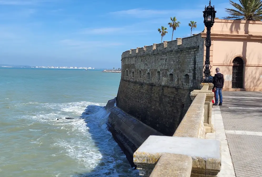
Because the promontory takes the full force of the Atlantic swell, the fort was built from local piedra ostionera (porous marine shell-limestone) on an irregular, nearly triangular plan pointing seaward to the northeast and northwest. Its outer ramparts slope in a steep talus above a low stone breakwater platform that absorbs the waves before they hit the main wall.

Heavy seas repeatedly battered the masonry over the following century. Three prominent 18th-century military engineers carried out major repairs on the sea walls and added an upper esplanade with a barbette battery (batería a barbeta) so guns could fire over the parapet rather than only through fixed slots:

  • Ignacio Sala, who worked on Cádiz's maritime fortifications in the early Bourbon period
  • Juan Zapatero, who reinforced the battered sea-facing masonry
  • Antonio Hurtado, who continued the 18th-century structural repairs

Pair an afternoon exhibition check with the seafront walk

Because the interior opens only when the Sala Tía Norica or courtyard has a scheduled exhibition or performance, build it into a walk between Alameda Apodaca and Parque Genovés. Even when the doors are closed, the exterior walk along the sea wall shows how the pointed talus and lower breakwater split the Atlantic swell.

Inside the walls: casemates, powder store and carrier pigeons

Behind the sloped sea wall rises a long gallery pierced by gun embrasures (cañoneras) and topped by a camino de ronda (parapet walk) looking out across the bay mouth. Along the outer flanks sit rows of vaulted casemates, while the centre of the enclosure still preserves its historic polvorín (gunpowder magazine) almost intact.

The southern side of the bastion faces the city and is closed off by service buildings, including the former guardhouse (cuerpo de guardia), the pump house (casa de bombas) and two 19th-century pavilions. Before its military role ended, the enclosure served several practical army functions:

  • Infantry and artillery barracks (cuartel) housing troops assigned to the northwest sea front
  • Military engineers' workshop (maestranza de ingenieros) for maintaining fortifications and equipment
  • Carrier-pigeon dovecote (palomar del servicio colombófilo) operated by the Corps of Engineers for military communications

From unrealized sea museum to cultural venue

The fortress is protected under Spain's 1949 Castles Decree and was declared a Bien de Interés Cultural (code RI-51-0007562) on 29 June 1985; it also forms part of the historic site of the 1812 Cortes and Constitution across Cádiz and the bay. In the second half of the 1980s the bastion underwent a full architectural restoration to house a planned Museo del Mar (Museum of the Sea).

That permanent museum never opened, despite the building works being completed. Instead, the municipality adapted the restored spaces for public culture: the Sala Tía Norica — named after the puppet tradition preserved at the Museo del Títere — hosts temporary art and history exhibitions, and the wide central courtyard, shaded by palm trees, stages open-air concerts, plays and Carnival events.

Planning your visit

The Baluarte de la Candelaria stands on Alameda Marqués de Comillas, s/n, with adapted step-free access from the waterfront promenade. Unlike monuments with fixed daily ticket desks, the bastion opens only during temporary exhibitions and scheduled cultural events, so check the municipal programme or call +34 956 808 472 before setting out; if the gates are shut, you can still trace its pointed oysterstone ramparts on the Cádiz seafront walk.

Reporter notebook

Insider tips

Booking tip

Call or check the municipal calendar before making a special trip

Hours and admission vary with each exhibition, concert or theatre production. Call +34 956 808 472 or check the city council's cultural listings before you go so you do not arrive between exhibitions.

Photo spot

Frame the pointed sea wall from the promenade toward La Caleta

Walk a short distance southwest toward Parque Genovés and look back at the northwest flank. From here you can see the sloped piedra ostionera rampart, the lower wave-breaking platform and the row of gun embrasures beneath the parapet walk.

Practical information

Opening hours
Open during exhibitions and cultural events; check municipal schedule before visiting
Admission
Variable by exhibition or event (confirm on the municipal listing before you go)
Address
Alameda Marqués de Comillas, s/n, 11004 Cádiz, Spain View on Google Maps

Tags

bastion fortress 17th century bien de interes cultural cultural venue seafront

Frequently asked questions

When was the Baluarte de la Candelaria in Cádiz built?

It was built in 1672 on the initiative of the governor of Cádiz, Diego Caballero de Illescas. Positioned on a rocky promontory between the San Felipe bastion and the defences near La Caleta, its cannons guarded the natural entrance channel to the port of Cádiz.

Can you visit the Baluarte de la Candelaria inside?

Yes, when an exhibition or cultural event is on. The bastion is not open on a permanent daily sightseeing schedule; instead, its Sala Tía Norica exhibition hall and palm-lined courtyard open for temporary shows, theatre, concerts and Carnival events.

How much does entry to the Baluarte de la Candelaria cost?

Admission depends on the programme running at the time. Check the current municipal schedule or call +34 956 808 472 to confirm times and whether a specific concert, play or exhibition requires a ticket.

Where is the Baluarte de la Candelaria located in Cádiz?

It stands on the northwest seafront of the old town at Alameda Marqués de Comillas, s/n (11004 Cádiz), right between the Alameda Apodaca promenade and Parque Genovés.

What was the Baluarte de la Candelaria used for before becoming a cultural centre?

Built as a coastal artillery bastion in 1672 and reinforced with a barbette battery in the 18th century, it later served as barracks, a workshop for military engineers, and a dovecote for the army's carrier-pigeon service. In the late 1980s it was restored for a planned Museum of the Sea that never opened.

Is the Baluarte de la Candelaria accessible for visitors with reduced mobility?

Yes. The municipal tourism office lists adapted access for the venue at its entrance on Alameda Marqués de Comillas.

Further reading

Sources

15 references Show
  1. institucional.cadiz.es (opens in a new tab)

    “Fue construido en el año 1672 por iniciativa de don Diego Caballero de Illescas, cuando era gobernador de la plaza, con la intención de proteger la entrada natural al puerto de Cádiz.”

  2. institucional.cadiz.es (opens in a new tab)

    “El baluarte de La Candelaria formaba parte del frente marítimo de la Bahía que protegía la entrada al puerto y el frente noroeste de la ciudad.”

  3. institucional.cadiz.es (opens in a new tab)

    “Dada su posición, sufrió los continuos embates del mar, siendo ingenieros militares de la talla de Ignacio Sala, Juan Zapatero y Antonio Hurtado los que ejecutaron las reparaciones.. En el siglo XVIII se montó una explanada con batería a barbeta.”

  4. institucional.cadiz.es (opens in a new tab)

    “Ha servido de cuartel, maestranza de ingenieros, palomar del servicio colombófilo del cuerpo de ingenieros.”

  5. institucional.cadiz.es (opens in a new tab)

    “Es de planta irregular y adopta forma apuntada para afrontar la fuerza del mar. Su muralla forma talud y en la parte inferior muestra una plataforma a modo de rompiente del oleaje. Sobre la muralla se eleva una crujía con cañoneras en cuya parte superior se sitúa el camino de ronda. El conjunto queda cerrado, en la parte que mira a la ciudad, por diversas dependencias como el cuerpo de guardia, la casa de bombas, etc…”

  6. institucional.cadiz.es (opens in a new tab)

    “Posee una Sala denominada "Tia Norica" habilitada para exposiciones, así como un gran patio con palmeras donde se celebran conciertos, obras de teatro y carnaval.”

  7. Turismo de Cádiz (opens in a new tab)

    “Sobre un saliente rincón del terreno, en 1672, se construyó este baluarte, que tiene una posición estratégica, entre el de San Felipe y las fortificaciones cercanas a la Caleta, y que representó una gran mejora para la protección del frente occidental. Se trata del emprendimiento defensivo más ambicioso realizado en Cádiz en la segunda mitad del siglo XVII y el mejor ejemplo de este tipo que se conserva en la ciudad.”

  8. Turismo de Cádiz (opens in a new tab)

    “Una serie de casamatas se organizan en el costado de los muros externos, y el recinto está bordeado por dos pabellones del siglo XIX.”

  9. Turismo de Cádiz (opens in a new tab)

    “Horario: Abierto durante exposiciones Horarios a consultar Tarifas: A consultar Servicios: Dirección: Alameda Marqués de Comillas, s/n (Acceso adaptado)Teléfono: +34 956 808 472”

  10. upo.es (opens in a new tab)

    “El baluarte tiene una planta casi triangular, con el lado sur abierto hacia la ciudad y los lados nordeste y noroeste ofreciendo fachada hacia el mar. Su muralla forma talud y en la parte inferior muestra una plataforma a modo de rompeolas. En su zona central se conserva casi intacto su polvorín.”

  11. upo.es (opens in a new tab)

    “Materiales de construcción Piedra ostionera.”

  12. upo.es (opens in a new tab)

    “En la segunda mitad de la década de los 80 del siglo XX se proyectó la instalación en el baluarte del Museo del Mar. Nunca llegó a inaugurarse a pesar de que se llevó a cabo la restauración y adecuación del baluarte para esta función. Sin embargo, ocasionalmente, se celebran aquí exposiciones de carácter temporal.”

  13. upo.es (opens in a new tab)

    “Incluido dentro de la Declaración genérica del Decreto de 22 de abril de 1949, de la Ley 16/1985 sobre el Patrimonio Histórico Español (Bien de Interés Cultural inscrito en el BOE del 29/06/1985, Nº155), y bajo el reconocimiento especial otorgado a los castillos por la Junta de Andalucía en 1993. Además, se encuentra inscrito en la Base de Datos del Patrimonio Inmueble de Andalucía con el Código: 110120059.”

  14. Wikipedia (opens in a new tab)

    “Parte de Sitio histórico de los lugares de las Cortes y la Constitución de 1812 en San Fernando, Cádiz y La Bahía Bien de interés culturalPatrimonio histórico de EspañaCategoría MonumentoCódigo RI-51-0007562Declaración 29 de junio de 1985”

  15. Wikipedia (opens in a new tab)

    “Aprovechando una elevada punta de tierra, fue construido en 1672 por iniciativa del gobernador de la plaza Diego Caballero de Illescas. Protegido por un resistente muro que hace de rompeolas, con sus cañones se dominaba el canal de acceso al puerto.”